THOUSAND ISLANDS
- Jhalak
- Mar 1, 2022
- 2 min read

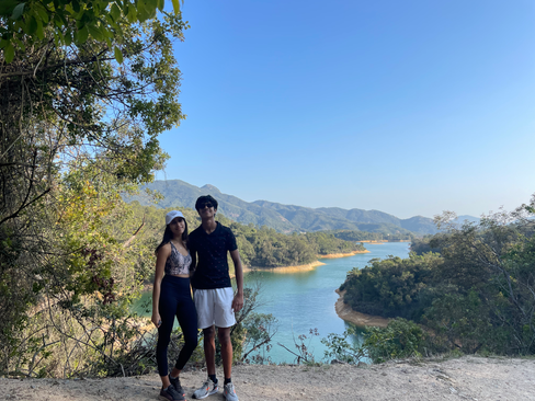
The Tai Lam Chung Reservoir, commonly referred to as the 'Thousand Islands Lake' is probably the most scenic view we have seen in Hong Kong. This reservoir was built after the Second World War and consists of a total of 4 dams. The construction was completed in 1957. When looked at from afar, it appears to be a lake of countless small islands. The 'islands' used to once be hills before the Tai Lam Chung Valley was flooded. The 'Thousand Islands Lake' is named after a similar reservoir in the Zhejiang Province in China where 1,078 large islands dot the lake and a few thousand smaller ones are scattered across it.

Difficulty Rating: 5/10 (the hike is mostly a leisurely uphill walk until the path splits up to a dirt road which is rocky and sandy for about 20 minutes until you reach the viewing point)
Duration: 3 hours (including breaks and viewing time)
Cell Service: 5/5
Instagrammability: 5/5 (this is definitely the most Instagrammed reservoir in Hong Kong, and the views just keep getting better and better as your reach the top)
How To Get There:

Once you exit from F2 at Tuen Mun Station, take a left onto Ho Pong Road, then take a right by the Wellcome. You will them see a GMB 43 bus terminus.
Get off on So Kwun Wat Tsuen Road which is close to the starting point of the hike.
Follow the paved road until you come across a sign towards Maclehose Trail, continue along the Maclehose Trail section 10 (image 1).
The official start of of the trail is marked by a trailhead (image 2). From here onwards, just continue following the signs towards 'Reservoir Islands Viewpoint'.


About 10 minutes from here, you will come across a bridge to your right (image 3). There were lots of people who had climbed over the bridge to have a picnic on the grass and just soak in nature. If you decide to just keep going instead, continue following the sign towards 'Reservoir Islands Viewpoint'.
After about 30 minutes on the path, you will reach a big circular space where you can take a rest and admire the views (image 4).

From the resting point, take the dirt road to your right by the blue toilet instead of the paved path on the left (image 6).


Below are some pictures from our way up until the start of the dirt road!


From the start of the dirt road until the beginning of the steps that lead up to the viewpoint (image 8), it is about 10-15 minutes of hiking which involves uneven stairs and rocky surfaces (image 7).
Once you've reached the beginning of the steps (image 8), you are only a few minutes or 200 meters away from the most breathtaking view ever!


There is plenty of space at the top to climb down towards the edge of the cliff and sit on a rock facing the views. If you reach around sunset, the sky will be lit in beautiful colours!

To return, take the same route back down to the start of the trail. Either take the GMB 43 or a cab back to Tuen Mun MTR station.

![LONG KE WAN [CAMPING]](https://static.wixstatic.com/media/ad293b_005925ed806543dc882992b64b2aa8b2~mv2.jpg/v1/fill/w_980,h_390,al_c,q_85,usm_0.66_1.00_0.01,enc_avif,quality_auto/ad293b_005925ed806543dc882992b64b2aa8b2~mv2.jpg)

You have done an amazing job with this website!! Taking Exit C1 at Tuen Mun MTR will take you to the bus terminus where you can find GMB 43. This might be easier than taking exit F2.